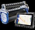
Gamma-ray sensors for gathering soil, sediment, and mineral composition
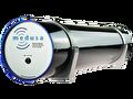
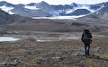
Walk, drive or fly. Collect high-resolution data with a lightweight, rugged and easy to use sensor.
The soil is ticking
Every soil contains naturally occuring radionuclides. With the Medusa sensor, even the slightest variations in radionuclide concentrations within the soil can be detected, offering valuable insights into the soil's composition.
Applications
Soil & sediment mapping
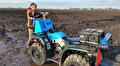
Soil composition is crucial for professionals like soil scientists, agronomists, environmental scientists, and farmers. Conventional methods provide limited insights into soil heterogeneity. Our advanced sensors enable digital mapping of soil texture, revealing genuine field diversity for informed decision-making in agriculture, land management, and environmental conservation.
Contamination mapping
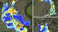
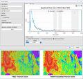
Contamination of soil and sediments by heavy metals and organic compounds poses significant environmental and economic concerns, particularly in floodplains and waterbodies. Gamma-ray sensors have become an effective means of accurately mapping the distribution of soil and sediment contamination, offering dependable and comprehensive data on spatial variations which are used to manage and dispose of contaminated sites.
Mineral exploration and remediation
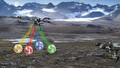
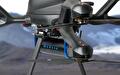
Gamma-ray sensors traditionally used in small aircraft for geophysics can now be deployed under drones. They provide valuable insights into the composition and structure of the Earth's subsurface, enabling geologists to detect, map, and remediate various elements and minerals. This capability greatly facilitates mineral exploration and contaminated site remediation efforts.
mDOS & Gamman
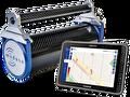
mDOS
Whether doing an airborne survey, locating a lost source with a UAV, or using our detector for a handheld survey for mapping the environment, you can count on using the same familiar interface. mDOS is developed for in-the-field usage. Optimized for real-time monitoring, ease of use and automating your survey workflow.
GammAn
GammAn is our comprehensive post-processing software tailored specifically for analyzing measurement results obtained from our gamma-ray detection systems.
Both mDOS and Gamman have been developed with a focus on user-friendliness, ensuring that users of all skill levels can effortlessly navigate and leverage the full potential of our detection systems. Whether you are a seasoned expert or new to gamma-ray analysis, our software packages provide the tools you need for accurate measurements and meaningful data interpretation.
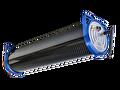
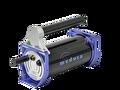
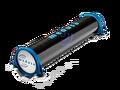
Gamma-ray sensors
Medusa specializes in producing gamma-ray survey sensors optimized for geophysical applications, whether terrestrial or aerial. We believe these systems should be user-friendly and hassle-free, enabling you to concentrate on your survey, not on managing your equipment. Simplify your surveys with our intuitive and lightweight gamma-ray sensors.
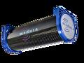
Medusa Radiometrics leads the way
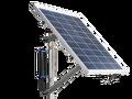
Enhance your business with maps created by the finest gamma-ray spectrometer available. Our lightweight, user-friendly gamma-ray sensors cater to various applications, including mining, agriculture, soil mapping, contamination mapping, nuclear research, and radiation safety. These sensors can be seamlessly integrated into survey vehicles such as aircraft, ATVs, and drones, or we can provide them as convenient handheld devices.
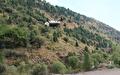
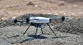
Drone-optimized gamma-ray sensor
Medusa gamma-ray sensors have set the industry benchmark for drone-based soil and geological mapping. To ensure a successful application of these sensors, it's crucial that they provide precise measurements of radionuclide concentrations in the soil.
Soil mapping made easy
What sets a Medusa detector apart?
We are committed to providing geophysicists around the world with efficient, lightweight, and robust gamma-ray survey systems that are easy to use, thanks to our innovative sensor design and smart data analysis models.
News & Blogs
Latest news
(This article is based on and inspired by the radiometrics workflow update released by Seequent for Oasis montaj 2025.2.)
At Medusa Radiometrics, we design and…

Latest news
Medusa Radiometrics is developing a new generation of gamma ray sensors through the ARGOS project (Advanced Radiation Gamma Observation System). The project aims to create both…